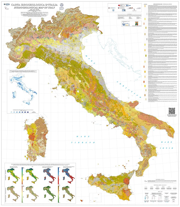
∇ – CII500K: Hydrogeological map of Italy – scale 1:500,000
• Provide a harmonized, national-scale overview of Italy’s groundwater systems through an open-access, scientifically curated platform.
• Support water planning, climate adaptation, and environmental governance with regularly updated and georeferenced hydrogeological data.
• Developed through a collaborative effort by ISPRA and the University of Milan, with contributions from basin authorities, ISTAT, and CMCC.
Beretta G.P., La Vigna F., Camera C.A.S., Gafà R.M., Citrini A., Martarelli L., Monti G.M., Roma M., Silvi A., Vitale V., Fiori C., Masetti M., F. Pascarella, Proietti R., Lo Faro S., Congi M.P., Gerardi M., Tersigni S., Baldoni T., Ramberti S., Barbato G., Mercogliano P., Giugliano G. (2025) – Carta Idrogeologica d’Italia alla scala 1:500.000 – 4 Fogli, Note integrative e tabelle online – Hydrogeological Map of Italy 1:500.000 scale. 4 Sheets, Supplementary Notes and online tables. ISPRA – Dipartimento per il Servizio Geologico d’Italia – Geological Survey of Italy. Roma
∇ – GIS in glaciology – Data sources, processing and use (2021)

• Learn how to reconstruct and compare glacier extent from 1954 to 2012 using historical and modern geospatial datasets in QGIS.
• Practice hands-on GIS skills including shapefile editing, WMS integration, area calculation, and map layout design.
• Explore real-world climate change impacts on Alpine glaciers through an interactive case study using official data from the Lombardy Geoportal.
Disclaimer: The Lombardy Geoportal website structure or WMS links may have changed since the exercise was created (2020–2021). Users are advised to verify updated access paths on the official portal.
