Andrea CITRINI, Georgia LAZOGLOU, Adriana BRUGGEMAN, George ZITTIS, Giovanni Pietro BERETTA, Corrado CAMERA (2024)
This study investigates how correcting weather radar precipitation data can improve hydrologic modeling in mountainous environments. The Valgrosina Valley (Italian Alps)—a dammed, hydropower-managed basin—is used as a case study. The research compares different bias correction techniques for radar data and tests their effectiveness in a semi-distributed hydrologic model (GEOframe). Accurate precipitation data are essential for improving low-flow simulation and water resource management in alpine catchments under climate stress.
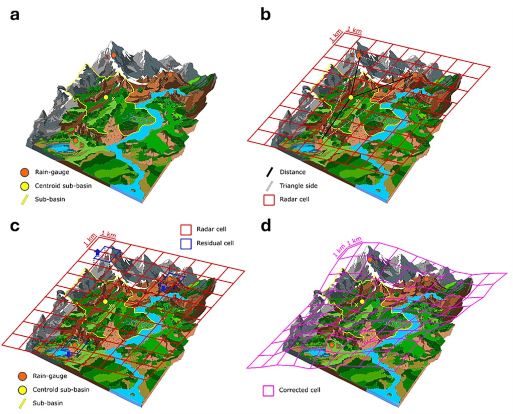
∇ – Methods
- Data Collection
- Hourly data (2010–2020) from 22 rain gauges and CombiPrecip radar estimates.
- Study area: Valgrosina basin, with Eita and Sacco streams feeding a hydroelectric dam.
- Radar Correction Techniques
- Point-based methods: Copula and Cumulative Distribution Function (CDF) corrections using TIN (triangular irregular network) interpolation.
- Spatial methods: Residual interpolation between radar and gauge data using:
- IDW (Inverse Distance Weighting)
- TPS (Thin Plate Spline)
- OK (Ordinary Kriging)
- DK (Detrended Kriging)
- Hydrological Modeling
- GEOframe model calibrated using corrected precipitation data.
- 21 sub-basins modeled with streamflow calibration/validation at Eita and Sacco.
- Performance evaluated using KGE, NSE, lnNSE, RMSE, PBIAS, and Composite Scaled Score (CSS).
- Nine hydrological signatures (e.g., baseflow index, runoff ratio) compared to observations.
∇ – Main Results
- Radar Bias Identified:
- Raw radar underestimated rainfall by ~20% across the basin.
- Spatial corrections outperformed both raw radar and point-based corrections.
- Best Method:
- Radar + OK (Ordinary Kriging) achieved highest correction performance (CSS = 0.87).
- Significantly improved low-flow simulations (e.g., lnNSE increased from negative values to >0.25).
- Hydrologic Model Performance:
- Radar + OK yielded the best discharge simulations for both Eita and Sacco basins.
- KGE > 0.75 and NSE > 0.59 in both calibration and validation phases.
- Low-flow periods accurately modeled, especially with Radar + OK and Rain Gauge TIN.
- Hydrological Signature Analysis:
- Radar + OK consistently showed best match with observed discharge characteristics.
- Some limitations noted for baseflow index and half-flow timing, especially in snowmelt periods.
∇ – Conclusion
This study confirms that bias-corrected radar precipitation, especially using spatial methods like ordinary kriging, can significantly enhance hydrologic model performance in mountainous regions. The approach is operationally feasible and robust, particularly important for managing water resources under climate variability. Future work could extend the methodology for real-time forecasting and hydroelectric operations in alpine basins.
∇ – Resources
Citrini, A., Lazoglou, G., Bruggeman, A., Zittis, G., Beretta, G. P., & Camera, C. A. (2024). Advancing Hydrologic Modelling Through Bias Correcting Weather Radar Data: The Valgrosina Case Study in the Italian Alps. Hydrological Processes, 38(11), e15339.

Leave a comment